
The best way to know a city is to walk her streets.
Armed with that thought and a faint memory of Kevin Lynch's The Image of the City - we headed off with 40 students in tow, walking from the Pullman Hotel to their project site. Along the way, we aimed to point out EDGES and how they differed from PATHS, and how NODES are quite distinct from LANDMARKS (although some nodes are also landmarks, and vise versa). We also talked about how landmarks are not always built elements, or prominent structures in the urban landscape - a favourite eating place can be a social landmark such as the Open Air market, which was a landmark from my school days; stopping there for a drink before heading home on a public bus. It was also a node as the bus terminal was next to the market. All the while, the fire lookout tower loomed high above the market roofs - it is one of a pair of fire lookout towers (it’s companion is at the end of Jalan Padungan). These two towers defined the extent of Kuching town and her DISTRICTS for many years; the Main Bazaar, Chinatown, India Street, the Golden Triangle, and the Administrative Centre.
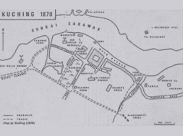 |
| I was pleasantly reminded that there used to be a river (Kuching) near the Tau Pek Kong temple, I recall a petrol station there in my childhood. |
 |
| They were excited to be out and about, a local guide called out 'I have not seen this for a long time, keep it up' - I think he meant tourists/visitors roaming our streets. |
Since the walk was expected to take about 90 minutes (in the rain) - we devised a ‘walking’ quiz; many of the answers can be found during our excursion. some of the questions are:
- Where would you find Corinthians in Kuching?
This one was to make sure they remembered their lessons from Architecture History - I read that this building was originally designed as an Art Gallery (perhaps for the Ranee Sylvia?)
- Get a mehndi tattoo.
This one is part of the immersive experience.
- Why is it called Wayang Street?
The companion structure to the temple is often overlooked, we wanted them to see hidden urban patterns and links.
- What's the local name for KaiJoo Lane, and why?
Many place and street names were given based on original features, buildings or people of the place; Upper China Street was known as (insert Chinese characters for me please) my mom still refers to Bampfylde Road as (mandarin characters) or Water Reservoir Road.
While the quiz was conducted like a game, it teaches the students to delve beneath the surface to uncover history and stories which might guide and enrich their design narrative. It is also the type of learning that you have, when you are not aware that you are learning, hopefully it teaches them to be intuitive in their design response.
We shall see.
 |
| This photo must have been taken before Electra House was completed, here you can only see the Bank Building behind |
 |
| One of my earliest memories of the Open Market was the bus terminal next to it; I loved the economy and the elegance of the concrete bus shelter (since demolished) |
No comments:
Post a Comment